That signal was an emailed message to voters in The Gap that he would ensure that work would begin this year “on a dedicated Local Neighbourhood Plan for The Gap - a planning blueprint providing peace of mind that the lifestyle of this wonderful suburb is representative of what locals want - now and into the future.”
But he is still refusing to commit to “calling in” the development so the planning application can be re-assessed by the Government – a commitment already made by his main rival, Labor’s Kate Jones.
The fact that the approval by Brisbane City Council for 980 homes has ignored the major restrictions placed on the land by the council’s own local neighbourhood plan demonstrates that the plan was not worth the paper it was printed on.
Using Mr Newman’s own terminology, the Ferny Grove/Upper Kedron Local Neighbourhood Plan proved worthless as a planning blueprint and failed to protect the lifestyle of this suburb despite it being representative of what locals want - now and into the future.
So Premier Newman is offering residents a promise to begin work on a plan which could prove to be equally ineffective.
Mr Newman’s email was timed to coincide with a meeting of local residents wondering what options they have in continuing to fight the mega-suburb.
There are a lot of votes involved in the issue, as demonstrated by the fact that more than 1,500 people “like” the Save The Gap facebook page.
In May 2014, when Cedar Woods Properties Ltd announced it had reached an agreement to buy the land, Brisbane’s LNP Lord Mayor, Graham Quirk, endorsed the plan for a massive suburb despite the local plan for the area restricting development to about 75 hectares of low density housing in the north-east corner of the 227 hectares of land.
He said "Brisbane City Council welcomes the entry of major listed developer Cedar Woods to Brisbane with the purchase of the Upper Kedron site. The development will be a significant project for the City.
“Brisbane City Council looks forward to working with Cedar Woods in the next phase of the project and with the aim of creating a high quality master planned community for the City."
So Mr Quirk locked the city council and his LNP colleagues into supporting the development . That would seem to include the Premier.
Cedar Woods told potential investors at the time of the Lord Mayor’s backing: “Rezoning anticipated within 12 months (strong Council & State Government support).”
For Cedar Woods to be able to report in an Australian Stock Exchange document that it had not just State Government support but “strong” support must surely mean it had a pledge of some sort from the Newman Government.
This would explain why the Premier has refused to act against the development.
Cllr Milton Dick told Brisbane City Council in December: “The LNP received five donations from the owner of the Cedar Woods property just prior to its value increasing from $4 million to $64 million.”
The owner at that time was Ian Macallister who signed an infrastructure agreement for the land with the council.
The land is now owned by Huntsman Property Pty Ltd, an offshoot of Cedar Woods Properties Ltd, of Western Australia, which bought the land from Mr Macallister.
I asked the company whether Cedar Woods Properties Ltd, Huntsman Property Pty Ltd, any company associated with Cedar Woods Properties Ltd or any directors of such companies had made a donation or donations to any fund or organisation associated with the Lord Mayor of Brisbane, the Premier of Queensland or the Liberal National Party.
No response has been received yet.
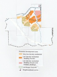
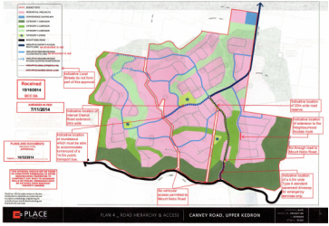
How does the council’s local neighbourhood plan compare with the plan approved by the council?
The plan on the left is the neighbourhood plan for the land in question. Only the coloured areas are to be developed.
Compare that with the map on the right of the approved development. Areas marked pink will be developed with 980 homes.
The coloured areas occupy about a third of the 227 hectares involved in the application – about 75 hectares. The rest is zoned rural or environmental.
The developable area in the neighbourhood plan is not quantified but as can be seen from the map, it would seem that about a fifth of the area for housing is for 16 homes per ha, about two fifths for 12 homes per ha and about two fifths for 5 homes per ha.
It’s a very rough calculation but it would total about 750 homes.
There are additional limitations. The green shading on some of the light yellow areas means development has to be located at least 15 metres vertically below any ridgeline – and there are several ridgelines.
This might reduce the number of home to around 700 rather than the 980 approved.
The Save The Gap organisation believes the number should be as low as 500 if, as planned, access to the suburb is only through the already busy streets of existing developments to the north.
END
http://us10.campaign-archive2.com/?u=53da90cca90ec3f2b76704851&id=d940bf221d&e=abea116559
www.brisbane.qld.gov.au/.../20141222_-_council_minutes_-_9_december


 RSS Feed
